Drones Transforming Environmental Conservation Efforts
Overview
This article explores the transformative role of drone technology in environmental conservation, highlighting its applications in wildlife monitoring, ecosystem mapping, and poaching prevention. Readers will learn about the various types of drones used in these efforts, the advantages they bring in data accuracy and efficiency, and the promising future trends that could further enhance conservation initiatives. By understanding these developments, readers can appreciate how drones are revolutionizing the way we protect our planet.
Table of Contents
- The Role of Drones in Environmental Conservation
- Types of Drones Used in Conservation
- Fixed-Wing Drones
- Multirotor Drones
- Marine Inspection Drones
- Applications of Drones in Environmental Conservation
- Forest Management
- Coastal Restoration
- Wildlife Surveys and Research
- How Drones Improve Data Accuracy and Access
- The Future of Drone Technology in Conservation
- Integration of AI and Machine Learning
- Enhanced Sensors and Imaging Technology
- Regulatory Support and Infrastructure Development
- Take Action for Our Planet: Embrace Drone Technology!
The world of environmental conservation is rapidly evolving, and one of the most exciting developments in recent years has been the integration of drone technology. Drones have proven to be essential tools in various conservation efforts, enabling researchers and environmentalists to gather data, monitor ecosystems, and even combat poaching with unprecedented efficiency. In this article, we will delve into how drones are making a difference in environmental conservation, the different types that are being used, and what the future holds for this tech-savvy approach to protecting our planet.
The Role of Drones in Environmental Conservation
Drones, also known as unmanned aerial vehicles (UAVs), have opened up new possibilities for environmental conservation by offering aerial perspectives and capabilities that ground-based methods cannot achieve. Here are some key roles that drones play in this field:
- Monitoring Wildlife: Drones equipped with cameras can capture images and videos of wildlife in their natural habitats without disturbing them. This non-intrusive method helps researchers gather data on animal behavior and population sizes.
- Mapping Ecosystems: Drones can create high-resolution maps of various ecosystems, such as forests, wetlands, and coastal areas. This data is vital for assessing the health of specific habitats and planning conservation efforts.
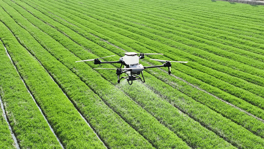
- Sustainable Agriculture: In agriculture, drones can monitor crop health, helping farmers make informed decisions about resource usage, pest management, and yield optimization. Technologies like the DJI Agras T100 agricultural drone are leading innovations in this area.
- Combatting Poaching: Drones provide invaluable assistance in conservation areas prone to poaching. They can monitor vast areas with ease, providing real-time data about potential threats and ensuring the safety of endangered species.
- Environmental Assessment: Drones offer a way to assess areas affected by natural disasters or human activity by capturing aerial footage that can be used to plan recovery efforts.
Types of Drones Used in Conservation
Not all drones are created equal, and different types serve specific purposes within environmental conservation. Here’s a closer look at some common types:
Fixed-Wing Drones
These drones are ideal for long-range missions and can cover large areas without the need for frequent recharging. They have a longer flight time and can gather data over vast expanses, making them crucial for mapping and monitoring ecosystems.
Multirotor Drones
Multirotor drones, such as quadcopters, are highly maneuverable and suitable for detailed inspections of specific locations. They can hover in place and offer high-resolution imagery, which is valuable for wildlife monitoring and habitat mapping.
Marine Inspection Drones
These specialized drones are designed specifically for inspecting marine environments. Equipped with cameras and sensors, marine inspection drones can monitor coral reefs, submerged structures, and marine life. They are essential in assessing the health of marine ecosystems and generating data for conservation planning.
Applications of Drones in Environmental Conservation
Drones are being utilized in numerous ways to support environmental conservation efforts worldwide. Some notable applications include:
Forest Management
Forests are vital to our planet's health, and drones are helping manage these ecosystems more effectively. Through aerial surveys, conservationists can:
- Monitor deforestation rates.
- Track forest health and biodiversity.
- Assess the effectiveness of reforestation efforts.
Coastal Restoration
Drones are also instrumental in coastal restoration projects. They facilitate the monitoring of:
- Beach erosion.
- Habitat loss.
- Coral reef health.
Wildlife Surveys and Research
Conducting wildlife surveys is often labor-intensive and time-consuming. Drones simplify this process by allowing researchers to:
- Access remote and difficult-to-reach habitats with minimal disturbance.
- Collect high-quality data for analysis.
- Engage in real-time monitoring of endangered species.
How Drones Improve Data Accuracy and Access
One of the significant advantages of using drones in environmental conservation is the ability to capture vast amounts of data with high accuracy. Traditional methods of data collection rely heavily on human resources and can be prone to errors. With drone technology, the potential for more accurate data collection methods includes:
| Data Type | Traditional Method | Drone Method |
|---|---|---|
| Wildlife Population Tracking | Ground-based surveys | Aerial photography and video |
| Habitat Mapping | Field studies | High-resolution aerial mapping |
| Environmental Changes | Manual monitoring | Real-time data collection |
| Resource Assessment | Time-consuming evaluations | Quick aerial surveys |
The Future of Drone Technology in Conservation
The future of drones in environmental conservation looks promising, as technology continues to advance. Here are some trends expected to shape the future of this innovative field:
Integration of AI and Machine Learning
As artificial intelligence (AI) becomes more prevalent, it is poised to transform drone operations. AI algorithms can enhance the analysis of collected data, improving the accuracy of predictions and assessments in conservation efforts.
Enhanced Sensors and Imaging Technology
The development of advanced sensors, such as multispectral and hyperspectral cameras, will allow drones to capture even more detailed information about ecosystems, enabling sophisticated analyses of plant health and soil conditions.
Regulatory Support and Infrastructure Development
Governments and organizations are starting to recognize the importance of drone technology in conservation efforts. This acknowledgment may lead to better regulatory frameworks that support drone usage while ensuring environmental protection. Additionally, the development of appropriate infrastructure for drone operations will encourage broader adoption of this technology.
Take Action for Our Planet: Embrace Drone Technology!
With the immense potential that drones offer for environmental conservation, the necessity to adopt these technologies has never been clearer. From wildlife monitoring to habitat mapping, drone applications provide invaluable insights and support vital conservation efforts. As we continue to face environmental challenges, leveraging innovative solutions like drones will be crucial in fostering a sustainable future for our planet. Join the movement to protect our earth and consider how drone technology can enhance conservation initiatives within your community.
Explore more about how drones can make a difference in environmental conservation by visiting Dronez Technologies and discover a world of possibilities!
Key Takeaways
- Drones enhance wildlife monitoring by capturing images and videos without disturbing animals, aiding in data collection on behavior and population sizes.
- High-resolution mapping of ecosystems is made possible with drones, providing essential data for assessing habitat health and planning conservation strategies.
- In agriculture, drones optimize resource usage by monitoring crop health, which helps farmers make informed decisions on pest management and yield improvement.
- Drones combat poaching by monitoring vast areas, offering real-time data to protect endangered species from threats.
- Different types of drones serve specific conservation purposes, including fixed-wing drones for long-range missions and multirotor drones for detailed inspections.
- Future advancements in drone technology will likely include AI integration and enhanced sensors, improving data accuracy and analysis in conservation efforts.
- Governments are beginning to support drone technology in conservation, which may lead to better regulatory frameworks and infrastructure development for broader adoption.
Pros and Cons
| Advantages of Drones in Conservation | Drawbacks of Drones in Conservation |
|---|---|
| Non-intrusive wildlife monitoring without disturbing habitats. | High initial costs for purchasing and maintaining drone technology. |
| Ability to create high-resolution maps for effective ecosystem assessment. | Potential regulatory challenges and restrictions on drone usage. |
| Real-time data collection enhances accuracy and efficiency. | Technical expertise required for operation and data analysis. |
| Support for sustainable agriculture through crop health monitoring. | Environmental concerns regarding drone noise and wildlife disturbance. |
| Assistance in combatting poaching by monitoring vast areas. | Dependence on weather conditions for effective operation. |
Linked Product

DJI Agras T100 Agriculture Spraying Drone - Ready to Fly Kit
The DJI Agras T100 Agriculture Spraying Drone is designed for efficiency in large-scale agricultural applications, capable of handling a maximum payload of 100 kg. It features a 100 L spraying tank with a high flow rate, allowing for faster and wider coverage, making it ideal for tasks such as spraying, spreading, and lifting. Equipped with advanced safety systems and obstacle detection technologies, the T100 ensures reliable operation while enhancing versatility across diverse agricultural scenarios.
View ProductWho It's For (And Not For)
Who It's For
- Environmental Researchers: Those involved in wildlife studies and ecosystem assessments can greatly benefit from the data collection capabilities of drones.
- Conservation Organizations: Non-profits focused on environmental protection can use drones for monitoring and mapping efforts, enhancing their conservation strategies.
- Agricultural Professionals: Farmers looking to optimize crop health and resource management can utilize drones for precision agriculture.
- Wildlife Protection Agencies: Organizations combatting poaching and protecting endangered species can leverage drones for real-time monitoring.
- Policy Makers: Those involved in environmental policy can use drone data to inform regulations and conservation planning.
Who It's Not For
- Individuals Unfamiliar with Technology: Those who are not comfortable using or operating technology may find drones challenging to integrate into their conservation efforts.
- Small-Scale Projects: Very localized conservation efforts with limited budgets may not have the resources to invest in drone technology.
- Organizations with Strict Budgets: Non-profits or groups with limited funding may struggle to justify the costs associated with drone purchases and maintenance.
- Areas with Regulatory Restrictions: Regions where drone usage is heavily regulated or prohibited may not be suitable for drone-based conservation efforts.
- Short-Term Projects: Initiatives that require immediate results without the time for data collection and analysis may not benefit from drone technology.
Frequently Asked Questions
1. How are drones used in environmental conservation?
2. What types of drones are commonly used in conservation efforts?
3. What advantages do drones offer over traditional data collection methods?
4. What are some applications of drones in wildlife conservation?
5. What does the future hold for drone technology in conservation?
Glossary
| Term | Meaning |
|---|---|
| Drones | Unmanned aerial vehicles used for various applications, including conservation. |
| UAV | Acronym for Unmanned Aerial Vehicle, another term for drones. |
| Wildlife Monitoring | The use of drones to observe and gather data on animal populations. |
| Mapping Ecosystems | Creating detailed maps of natural habitats using drone technology. |
| Multirotor Drones | Drones with multiple rotors, ideal for detailed inspections and photography. |
| Fixed-Wing Drones | Drones designed for long-range missions with extended flight times. |
| Marine Inspection Drones | Drones specialized for monitoring marine environments and ecosystems. |
| AI Integration | Incorporating artificial intelligence to enhance data analysis from drones. |
| High-Resolution Mapping | Creating detailed images and maps for better environmental assessments. |
| Coastal Restoration | Using drones to monitor and support the recovery of coastal ecosystems. |